Looking at Palomares Canyon Estates for privacy and breathing room, but unsure how access and safety stack up? You are not alone. Hillside living in Castro Valley offers seclusion and views, yet it also comes with unique road, utility, and wildfire considerations that affect day‑to‑day life, insurance, financing, and resale. In this guide, you will learn how to evaluate access and privacy with a pragmatic checklist you can use before you buy or list. Let’s dive in.
Palomares Canyon context
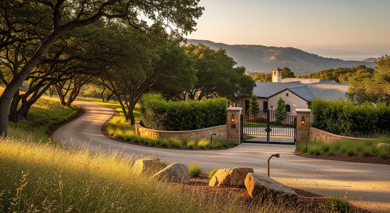
Palomares Canyon sits in the eastern Castro Valley hills, where steep slopes, winding canyons, and mature trees create a private, scenic setting. These same features increase attention on wildfire, erosion, and slope stability. Castro Valley is unincorporated, so many services, permitting, and road decisions run through Alameda County rather than a city. Start with county agencies for planning and road questions, including the Alameda County Planning Department and Public Works.
Homes here often sit on irregular lots with long or steep driveways. Some parcels back to open space, which boosts privacy while raising exposure to wildfire and geologic hazards. Understanding how the land sits, how you access it, and what you can change legally will help you weigh both lifestyle and long‑term value.
Access you can rely on
Public or private road
Access often determines daily convenience and emergency safety. Confirm whether the access road is public or private. Public roads are maintained by Alameda County. Private roads and shared driveways are maintained by owners or an HOA. Ask for the preliminary title report, any recorded road maintenance agreements, and county roadway information through Alameda County Public Works.
If access is private, verify who pays for maintenance, how decisions get made, and whether reserves exist for major work after storms. Request recent invoices, past repair records, and any engineering reports on the road or private bridge, if applicable.
Road width, grades, and turnarounds
Canyon routes are often narrow and winding. Long or steep driveways can slow two‑way traffic, parcel delivery, and emergency vehicles. Ask about minimum road widths, turnarounds, and gate clearances required by the county fire agency, and confirm whether gates include Knox access for emergency responders. If widths or turnarounds are substandard, budget for potential improvements that may require county permits.
Commute and regional connectivity
You are close to East Bay corridors, yet hillside routes can add time. I‑580 and I‑238 link Castro Valley to the greater region, and the Castro Valley BART Station provides transit into Oakland and San Francisco. Test peak and off‑peak drive times from the property to key destinations. If you rely on highways, check regional updates through Caltrans District 4.
Utilities and broadband
Most properties connect to Pacific Gas and Electric for electricity, some with overhead lines that require vegetation management. Review any fire‑hardening or tree‑clearing history and learn more about vegetation standards from PG&E. Water and sewer service can vary by parcel. Some homes use municipal service while others rely on septic systems. Ask for provider contacts, recent utility bills, and any septic inspection records.
Broadband can be limited in hillside pockets. Confirm available speed tiers and reliability directly with providers at the street address. Ask sellers for past outage history and any infrastructure upgrades.
Emergency access and evacuation
In hillside neighborhoods, evacuation routes matter. Single‑exit roads, locked gates, or private bridges can create choke points. Confirm marked evacuation routes and local wildfire plans through the relevant county fire agency. Start with the Alameda County Fire Department to understand defensible space, evacuations, and emergency access requirements in your area.
Ask whether any community gates have Knox boxes and whether your driveway accommodates fire apparatus turnarounds. If neighbors share a private road, verify that the maintenance agreement covers debris removal after storms and outlines who authorizes emergency repairs.
Privacy realities in the canyon
Physical privacy on hillside lots
Privacy comes from lot size, elevation, orientation, and vegetation. Homes perched above the canyon often feel visually secluded, yet sight lines from higher ridges can reach decks and yards. Vegetation screens help, but they are seasonal in some cases and must align with wildfire defensible space rules. Walk the property at different times of day to check views into and out of main living areas.
Legal limits, easements, and rules
Hillside parcels commonly include easements for utilities, access, or drainage. These can cross parts of a yard, which limits practical privacy or where you can add improvements. Zoning and setbacks guide what you and neighbors can build. There is typically no guaranteed private view protection under California law, so future permitted construction could change outlook or screening.
If an HOA or CC&Rs apply, review rules on fencing, vegetation height, and architectural review. These can both protect neighborhood character and restrict how you add privacy features.
Noise, acoustics, and testing times
Canyon acoustics can carry sound in unusual ways. Depending on orientation, you may hear I‑580, passing vehicles, or neighborhood activity. Visit at morning, midday, evening, and late night. Stand in outdoor areas important to you and note what you hear.
Hazards, insurance, and lending
Wildfire risk and defensible space
Hillside vegetation increases wildfire risk. Check your parcel’s designation on the CAL FIRE Fire Hazard Severity Zone map. In higher‑risk zones, insurers may price coverage differently or limit new policies. California law requires defensible space around structures, and local agencies may require additional fuel reduction. Obtain recent insurance quotes and ask sellers for renewal history and any defensible space inspection records.
Slope stability, seismic, and drainage
Steep terrain can present landslide and erosion risk, especially after heavy rain. Review regional context with the USGS Landslide Hazards Program. A geotechnical assessment is smart for most hillside properties, especially before additions, retaining walls, or site grading. For flooding, use FEMA’s Flood Map Service Center to check mapped zones, but also pay attention to local drainage patterns that may not appear on national maps.
Lending and title for private access
If you rely on a private road, most lenders will ask for recorded access rights and a road maintenance agreement. Some have minimum standards for width and turnarounds. Title companies also review easements and may require documentation that the road can be maintained. Bring your lender into the conversation early to avoid surprises.
Buyer due‑diligence checklist
Use this step‑by‑step list to evaluate a property before you write an offer.
Documents to request
- Preliminary title report showing access and utility easements.
- Recorded road maintenance agreements for any private road or shared driveway.
- CC&Rs or HOA rules, if applicable.
- Recent survey or plot map with setbacks, easements, and topography.
- Existing geotechnical report, or a plan to obtain one.
- Recent utility bills and provider contacts for water, sewer, electricity, and broadband.
- Fire insurance information, including renewal history and any defensible space reports.
- Permits and inspection records for prior work, including retaining walls or septic systems.
Inspections and specialists
- General home inspection plus roof, retaining walls, chimney, and any septic or well systems.
- Geotechnical or soils engineer for steep slopes or visible settlement.
- Arborist evaluation where large trees provide screening or pose hazards (check tree protection rules with the county).
- Fire risk and defensible space assessment through the local fire agency or a qualified contractor.
- Utility and broadband verification directly with providers at the property address.
On‑site checks
- Drive all approach roads at peak and off‑peak times, and in wet weather if possible.
- Confirm gate operation, Knox access, and vehicle turnarounds.
- Walk the lot to evaluate lines of sight, noise, and privacy from decks, yards, and primary rooms.
- Talk with neighbors or the HOA about road upkeep, storm response, past evacuations, and power or internet reliability.
Regulatory and permitting
- Confirm which county department issues building, grading, and tree permits for your parcel. Start with the Alameda County Planning Department.
- Check wildfire designations via CAL FIRE and understand local defensible space rules through Alameda County Fire.
- Verify permits needed for new fencing, retaining walls, site grading, or significant tree work.
Financial checks
- Ask your lender about private‑road underwriting standards and documentation.
- Obtain current insurance quotes and factor potential wildfire or slope mitigation costs.
- Price potential road, driveway, or drainage upgrades that could be required later.
Seller preparation checklist
If you plan to sell in Palomares Canyon Estates, preparing early can expand your buyer pool and protect your price.
Assemble documentation
- Preliminary title report, road ownership details, and any private road maintenance agreements.
- CC&Rs or HOA rules, if applicable, plus any architectural approvals for past work.
- Existing geotechnical reports and recent survey or plot maps.
- Utility provider list, recent bills, and any broadband service confirmations.
- Fire insurance declarations and renewal history.
Show mitigation and maintenance
- Document defensible space compliance and recent vegetation management. Reference PG&E’s vegetation standards if overhead lines are present.
- Provide receipts for road grading, culvert cleaning, or drainage improvements.
- Note any seismic or slope‑stability evaluations and completed repairs.
Set buyer expectations
- Clarify access details, gate operation, and emergency provisions.
- Outline utility sources, septic status if applicable, and typical service reliability.
- Share realistic commute and access notes for showings, including steep or narrow segments.
How we can help
Evaluating access and privacy in Palomares Canyon Estates takes local knowledge and a steady, detail‑oriented approach. Our team brings white‑glove guidance for hillside and acreage properties, from pre‑listing preparation to targeted buyer outreach. Whether you are weighing an offer or planning a sale, we will help you verify the right details and frame your home’s strengths with confidence.
Ready to talk strategy for your property or shortlist? Connect with The Kristy Peixoto Team to Schedule Your White‑Glove Consultation.
FAQs
How do I verify if my Palomares Canyon access road is public or private?
- Check your preliminary title report and contact Alameda County Public Works for roadway information, then review any recorded road maintenance agreements.
What should I ask about private road maintenance before I buy?
- Request recorded agreements, recent invoices, reserve details, and records of storm cleanup or major repairs to confirm both funding and decision‑making.
How does wildfire risk affect homes in Palomares Canyon Estates?
- Use the CAL FIRE Fire Hazard Severity Zone map to gauge risk, then obtain insurance quotes and confirm defensible space compliance with the local fire agency.
Do canyon homes face landslide or drainage issues?
- Hillsides can present slope and erosion risks; consult the USGS Landslide Hazards Program and consider a geotechnical evaluation plus a drainage review.
Is BART a realistic commute option from Castro Valley’s hillsides?
- Many residents drive to the Castro Valley BART Station; test your specific route for travel time and parking availability.
Can a gated private road affect my mortgage approval?
- Lenders often require recorded access rights and a road maintenance agreement, and some expect minimum standards for width and turnarounds, so confirm requirements early.